Archive
Size Comparison: ‘Tren Electrico’ in Phoenix, AZ

DATA IS KEY….
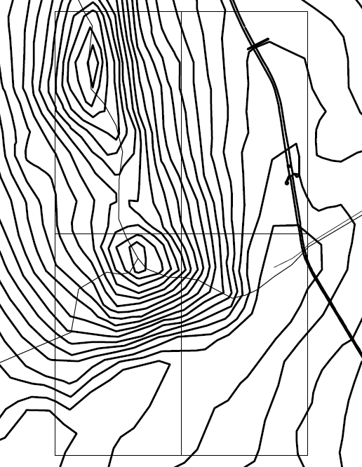
I have begun to retrace topographic lines taken from the following site: www.heywhatsthat.com which uses Google maps. This is more accurate than the IGN it seems. Accuracy is key for understanding the slopes in question. Data is key.


THESIS
The following proposal defends the concept Open Source Infrastructure as an appropriate alternative for city building in the developing world. In regions where piracy is prevalent and urban growth is defined as both informal and organic, a more punctuated and restrained form of public infrastructure is fundamental. If community participation is requisite in the installation of public works and are encouraged to expand upon and re-interpret designs unrestrained by copyright, an idiosyncratic urbanism ensues which is reflective of the community, advocates agency among the population, and strengthens local regard so often lost through large-scale government projects. This Open Source Infrastructure will exploit the propensity toward bootlegging and bricolage in the informal world, not just as a strategy for the dissemination of design, but as a device to guide smart growth through incremental change rather than wholesale redevelopment.
A series of urban design initiatives and interventions are proposed at nested scales of both complexity and completion. At the level of the neighborhood, open spaces within the dense environment of informal settlements will be re-appropriated, streetscapes redefined but left incomplete, and locations for public amenity re-established. The hand of the designer is “light” in this case. The re-direction of urban slum growth is then guided by small homeopathic interventions in key city nodes, paths, and edges. Connections are made between and within these innovative, publically sponsored projects. The designs are transparent and encourage re-adaptation and re-invention by the community they serve. Through this series of sporadic but guided designs that are easy to replicate, readapt, and redistribute; sustainable urbanism is catalyzed and disseminated through the mechanism of open exchange.
From Earth to The Pot: Paradigm Shift Project

Paradigm Shift Project: Villa Maria del Triunfo
Click here: http://www.theparadigmshiftproject.org/peru-food_security.html

CONCEPT: CONTOUR STRADEGY OF AMENITY DISTRIBUTION

PRELIMINARY CONCEPT
Today I met with Prof. Vekstein, MArch Thesis Chair. Although I want to fix all the ills of asentamientos humanos through a single design, I must narrow the scope. Keep in mind that municipalities and federal governments follow strict budgets, especially in developing nations with restricted means. Inspired by then mayor Luis Castañeda’s “Escaleras Solidarias” -which are a series of concrete stairs painted yellow- it was decided best to focus on this existing amenity for the project. While touring the sites, it was obvious that the stairs are more than circulation up and down the sandy hills. Rather, they serve as community spaces as children play and mothers chat.
People work in the city below. Daily, mothers and fathers walk up and down for work, food and play. The model now exists. Yellow stairs guide you to where everything else is. The problem: the walk. A new model is proposed based instead on the existing contours of residences. Horizontal links are proposed between these yellow stairs lifting amenity to the level of the residence.
Hypothesis: A series of plazas with bodegas and almacenes, infill housing of an improved state which serve as models to be replicated and adapted, lighting, and other civic elements. All of this along paths connecting existing stairways. These operations are incremental, each a layer of investment. First the path, then the lights, then the houses with squares. A large area is planned connecting several stairways. Scenarios must be put forth: If full funds are available, the entire project is completed as designed. If the budget is cut in half, parts of the paths and all of the lights are put in place to be completed with time. As opposed to PREVI however, plans are available to guide completion and imaginative alterations. As the house is a process rather than object, so shall be open space.
Green is the new color proposed. A new political move intended to be seen but contrasted with the existing. A green line in contrast to yellow. This is an incremental urban stradegy inteded to improve the quality of life in the neighborhood. At some point, people need to stay on the hillsides. Design for this.

MAP TRANSPORT SYSTEMS: SAN JUAN DE MIRAFLORES

In conversation with Prof. Kahatt, it was noted that the Tren Electrico rail line meets grade in two specific areas on it course. These are at the extremities of the rail line. The condition at these locations is a high wall separating access of the community from one side to the other. The oldest section of the rail line is to the south and could explain why it is not elevated. The north section, however, is walled perhaps due to the high incidence of crime. More research is needed. Above, in blue, are the proposed site locations of urban accupuncture. Two communities split by an expansive open space dedicated to high voltage tension cables called the “Torres de Melgar”.
